Active military service can give a person a unique perspective on life – for Tom O’Sullivan it has provided an understanding of how far the risks and stress of business are removed from life-or-death situations, something that has liberated him to push boundaries others might have shied away from.
Tom served in the Black Watch, leading operations in Afghanistan, before setting up his geospacial technology business, Animus Bytes. While he fully appreciates that the stakes in business can be high, his attitude towards calculated risk has created a business that is committed to a ‘try and fail’ philosophy, unafraid to take risks, but to learn from them, and to improve after every move.
Tom said:
“My time in the Black Watch grounded me in the stark reality of life-and-death situations, and an attitude of calculated risk-taking has formed the backbone of Animus’ culture – and, of course, I have tried to reflect this in our company values. This is so important for the work we do because without the appetite to take risks, we wouldn’t be able to develop technology with the potential to have a true societal and humanitarian impact.”
Geospatial technology has the potential to be a game-changer across many sectors. In logistics, for example, through the use of location data, companies can optimise routes and reduce fuel consumption, saving millions – if not billions – over time. Similarly, in agriculture, geospatial tech can advance farmers’ understanding of soil conditions and weather patterns, leading to a more efficient use of resources and higher yields.
But it’s not just about cost-saving – it’s also about creating new opportunities. Real-time location data can enable smarter urban planning, leading to cities that are not only more sustainable but also more attractive for investment.
At its core, it’s about making sense of complex data to solve real-world problems efficiently.
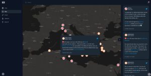
Having developed solutions across a number of sectors, Animus Bytes is currently working on a real-time migrant vessel tracker.
Tom said:
“In a world where migration crises are intensifying, Migrant Watch uses AI and other advanced technologies to identify migrants in urgent need of rescue at sea. It’s a timely solution aimed at preventing unnecessary loss of life by enabling quicker and more efficient rescue operations.
“The goal is to make Migrant Watch a comprehensive, real-time monitoring system that can be adopted globally. The humanitarian applications of geospatial tech, like Migrant Watch, have an equally important economic impact. By saving lives and aiding in disaster relief, we’re preserving human capital while also reducing the economic burden on governments and NGOs.
“So, when we talk about unlocking billions in economic benefits, we’re looking at a holistic picture that spans cost-saving, revenue generation, innovation, and long-term societal investment. But, if geospatial technology is to reach its full potential, it’s essential that we raise awareness of its current – and potential – uses among the business community and society.”
Animus Bytes’ target market is quite diverse, reflecting the versatile nature of geospatial technology, and looking at sectors that have a critical need for real-time, accurate location data. This includes maritime organisations for search and rescue operations, NGOs focusing on environmental conservation, and even urban planners working on sustainable city development.
The target market is united by a shared vision for leveraging technology to create a meaningful impact on society and human lives, and Animus Bytes is constantly refining its algorithms and looking to integrate more data sources like satellite imaging.
Tom added
“Beyond paying the bills and investing in growing Animus’ talent base, my focus is entirely on our contribution to society. Money doesn’t excite me – making things that solve real-world problems excites me.
“Migrant Watch, for example, has a clear humanitarian purpose – saving lives at sea. The value of a human life is immeasurable, and if our technology can contribute to that, then we’ve achieved something truly meaningful.
“We’re actively reaching out to maritime organisations, coastguards, and governmental bodies to showcase how Migrant Watch can make their rescue operations more effective.
“Geospatial tech also has applications for disaster relief coordination, such as in flooding monitoring and response, and it can also be used in environmental conservation, identifying unlicensed deforestation, for example, and in urban planning – to optimise the use of limited space.
“It has the potential to transform our society and our economy, but more awareness of its benefits needs to be generated. Advancements in technologies like AI and machine learning – coupled with the increased availability of satellite data – are ramping up the opportunities for the UK to leapfrog its competitors.
“If the UK commits investment to catalysing innovation in this sector, it can set a global example of how this technology can be utilised for economic and societal benefit – and reap the benefits in the process.”
To find out more about Animus Bytes visit www.animusbytes.com